Choquequirao Trek 4 Days – Tickets 2024 – Cusco
Choquequirao known as the Sacred Sister of Machupicchu, its name means Cradle of Gold and is today one of the most important archaeological complexes in the department of Cusco, in addition to having been a connection point between the Amazon jungle area and the Cusco city, was one of the last bastions of the resistance of the Incas against the Spanish.
It is located in one of the foothills of the Salkantay mountain range in the Santa Teresa district. To get there we need to travel from Cusco to Abancay to the town of Cachora.
The Choquequirao trek is undoubtedly one of the most beautiful roads in the Andes and the most intense full of places that are not visited as it is not a very commercial route and it does not have many towns on the route. This route will take you through unique and varied landscapes with nothing less than impressive scenery through the largest archaeological complex! Photographers will experience sheer ecstasy as they hike lonely, ancient trails – from picturesque grassy highlands to flourishing cloud forests, where lush rain forests meet colossal snow-capped mountains as we get to know the snowy Padreyoc and Corihuayrachina.
Where is Choquequirao Peru?
08710, Peru
Choquequirao is currently located in the district of Santa Teresa, province of La Convencion, department of Cusco, in Peru.
Choquequirao Archaeological Park Peru is located in the foothills of the Nevado Salkantay, in the Apurímac valley.
The Choquequirao Archaeological Park is located between the slopes and the top of the hill that bears the same name at 3104.09 m.a.s.l., in the Yanama mountain range, located in the Vilcabamba mountain range.
Choquequirao longitude and latitude
13.3950° S, 72.8722° W
The Choquequirao Archaeological Park is located at 13 ° 32 ' latitude and 77 ° 44' west longitud.
It is located at 3,033 meters above sea level in the mountains of the Salkantay Glacier.
What is Choquequirao?
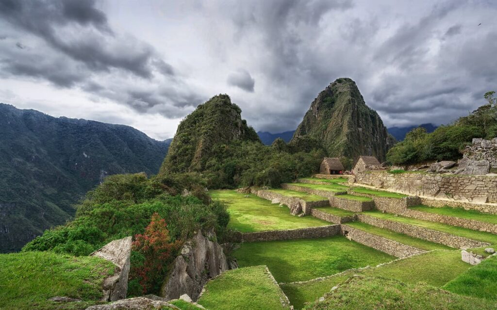
Choquequirao is an Inca urban center similar to Machu Picchu.
The similarity with Machu Picchu is due in large part to the similarity of the geography of the place where the enclosure was built.
According to various investigations, Choquequirao Ruins would also be a fortress and a ceremonial center. The truth is that due to its hidden location on a high and distant mountain; it was a strategic point for various purposes.
Over the years, like Machu Picchu, Choquequirao Ruins was abandoned and covered by the jungle until its re-discovery.
When was Choquequirao discovered?
The first explorer to visit a citadel called "Chuquiquirau" was the Spanish explorer Juan Arias Díaz Topete in the year 1710.
Then, in 1909, an American foreigner wearing a khaki hat, who asked some of the descendants of nearby families if they had heard of an ancient Inca city in the middle of the jungle, like Machu Picchu. Well, he's right, what's more, he's the same American in a khaki hat. This foreigner, hired a local shepherd as a guide, also paid him for some donkeys and they started walking. This explorer was Hiram Bingham. However, while Machu Picchu achieved full glory. The one that is considered his sacred sister (Choquequirao) was covered by the dense thicket of the jungle for much longer.
Choquequirao History
In Choquequirao, the Incas took refuge from the Vilcabamba valley after the arrival of the Spanish, in their last attempt to reconquer their kingdom. Its name means "Cradle of Gold" and its beauty and greatness is compared to Machu Picchu. Experts suggest it was constructed around the same time as Machu Picchu.
Origin of the Name of Choquequirao
According to studies, although Choquequirao was not a place of extraction of gold or silver, its name has sacred connotations. In the Aymara language, which was spoken in a large part of the southern Andes before the Incas, the term Choque designates gold and everything related to it. It refers to all things that shine, such as the sun, lightning, micaque stones flicker in the sun, and everything precious and of great value.
Its synonym in Quechua is Cori, el Oro. For its part, the term Quirao means "cradle of gold", a possible allusion to the numerous gold mines in this area that the Incas exploited considering them sacred. It should not be forgotten that the Inca was the son of the sun, inti on earth, and his wife, a reflection of the moon, Quilla.
History of Choquequirao during the Inca period (1438-1534)
It was a cultural and religious center for the region. Presumably this citadel was used as a checkpoint to ensure access to the Vilcabamba areas, which connected the jungle with other important centers such as Písac and Machu Picchu. It is also estimated that the citadel played an important role serving as a link between the Amazon jungle and the imperial city of Cusco.
Time of transition (1534-1572)
The young French historian E. Duffait points out, in his recently submitted doctoral thesis, that the conqueror Francisco Pizarro ceded to his brother Hernando the entire region of Choquequirao, which was then called Choquicarango or chuquierrango, which shows that the Spaniards knew this site little after his arrival in Peru in the 16th century.
History of the invasion of Choquequirao
Choquequirao is considered one of the last bastions of resistance and refuge for the Incas, who, on the orders of Manco Inca, left the city of Cusco to take shelter in the cities of the Vilcabamba region, when around the year 1535 Cusco was besieged by the Spanish people. It was in this place (and in general in the entire Vilcabamba valley) that Manco and the other Incas of Vilcabamba resisted the onslaught of the Spanish, until the capture and execution of Túpac Amaru I in 1572.
E. Duffait indicates that both Choquequirao and Machu Picchu were the personal royal residences of the Inca Tupac Yupanqui, which symbolized his power and acquired all their symbolic significance and importance after the death of the sovereign. His main function was to perpetuate his memory and understand the needs of the different members of his lineage, for the products that were made there. Thus, both sites had a highly ritual role.
References in colonial times
The first written reference to Choquequirao dates from the year 1768 and its author was Cosme Bueno, however the documentation was posted sideways and forgotten by the authorities and the general public. In 1790, Pablo José Origaín mentions in his "Compendium of Geographic News of Cuzco" a city that has been depopulated since ancient times with the name of Choqequirau.
Restoration of Choquequirao Archaeological Park in Peru
Former President of the Republic Pedro Pablo Kuczynski visiting the area where the Choquequirao cable car will be built to boost national and international tourism.
In 1834, José María Tejada (prefect of Cusco) travels to the citadel attracted by the legends about treasures in Vilcabamba; likewise in 1837, Leonce Angrand mapped the place for the first time, but his maps were also forgotten. It was not until 1909, the year that archaeologist Hiram Bingham and surveyor Clarence Hay (both Americans) visited Choquequirao and produced a detailed description of the site, that the citadel gained greater attention from archaeologists, the government, and tourists.10 The first excavations began several decades after Bingham's visit, around 1970; likewise, it was not until 1986, that the Peruvian government began the restoration work that made it possible, just some time ago, for people to reach the Inca city of Choquequirao, following in the footsteps of Bingham.
Currently, it is estimated that only 30% of the complex, which comprises some 1,810 hectares, has been unearthed and put into operation as a tourist area; The restoration was expected to be completed in 2011, taking even longer to study and understand its historical legacy.
What is the architecture like in Choquequirao?
Choquequirao has numerous Inca buildings. However, currently only 30% of its entire area has been excavated.
Its most important buildings are made of quartzite, cut in great detail. The rest of the walls are made of raw stone.
These walls were covered with clay both inside and out.
The walls of Choquequirao Ruins are believed to have been painted light orange. Although in reality there are few structures that continue with this coating.
What to see in Choquequirao Ruins?
The ancient city of Choquequirao has two main squares, temples, fountains, canals, workshops, warehouses, elite residences and more common ones.
The ceremonial center of Choquequirao is a large platform that can only be reached through a double jamb door.
The largest buildings in the area are the colcas (warehouses).
Like Machu Picchu, Choquequirao Ruins has structures that mark solar events such as solstices and equinoxes.
Choquequirao Altitude
Choquequirao is located at an altitude of 3,033 meters above sea level (9,951 ft).
Choquequirao is located between the jungle and the Peruvian Andes, and it has a great peculiarity: it can only be accessed by walking, on a 62-kilometer round-trip route and with descents and ascents of an elevation from the 1,400 meters above sea level (4,593 ft) to an elevation of 3,100 meters above sea level ( 10,170 ft) and vice versa.
How to pronounce Choquequirao?
To help you with the correct pronunciation of the word “Choquequirao”, here’s a breakdown of the word Choquequirao how to say it:
Sha-kay-ka-row
Notice how the “Cho-” part changed to “Sha-”? And how “-rao” changed to “-row”? This is all due to the pronunciation being derived from the indigenous language of Quechua.
Choquequirao Pronunciation Audio
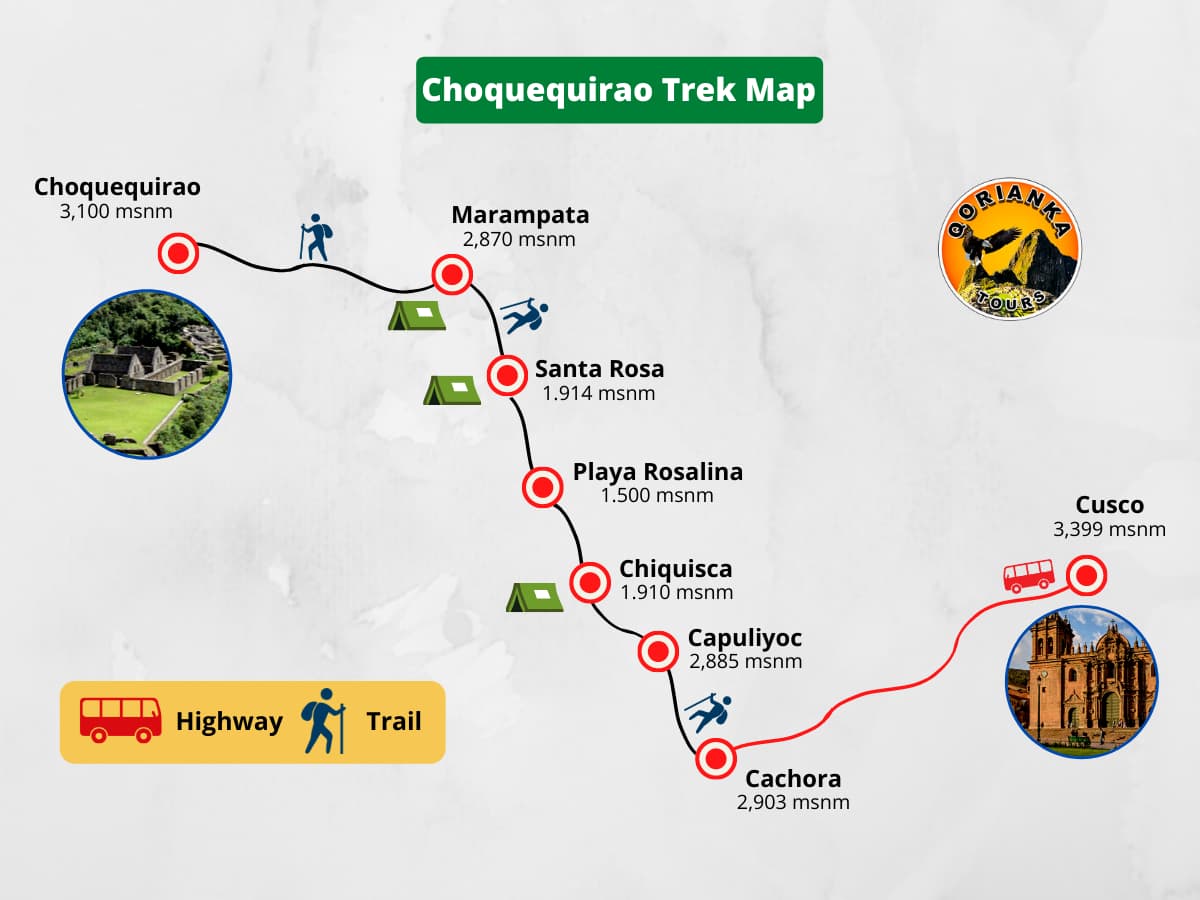
Our Adventure begins with the pick up at your hotel in Cusco, then we will board our bus in the direction of the town of Cachora, (Punta Carretera) where we will meet the rest of the Choquequirao Travel team, the muleteers, cooks and horses.
From this point we begin our walk through a beautiful Andean landscape and we will have a beautiful view of the Padreyoc and Wayna Cachora mountains. We will have an impressive view of the Apurimac valley from the viewpoint called Capuliyoc, then we will continue our walk until we reach Chiquisca where we will have our lunch.
Then we will continue our walk until descending to Playa Rosalina (1550 m.a.s.l.), which is the lowest point, from this place we will ascend for approximately 2 hours until we reach Santa Rosa, place of our first camp. (Lunch and dinner).
In Santa Rosa we can find the famous Cambrai, a drink made from sugar cane, which in large quantities can get us intoxicated.
Throughout the walk from Santa Rosa to Marampata we will have a beautiful view of the Apurimac canyon, we will cross small hunts such as Santa Rosa Alta and Huchuerta, once we reach Marampata which will be the place of our camp, we will have a little rest and then we will have a walk of approximately 1 hour and 30 minutes to the Inca city of Choquequirao.
When we get to Choquequirao we will have a guided tour of the most important areas of the place, such as the main esplanade, the Usno, the Workshops and the Sector of the platforms that are embedded in stone in the shape of Llamas.
After our visit we will return by the same road to Marampata for approximately 1 hour and 30 minutes, where we will have our dinner and our camp. (Breakfast, lunch and dinner).
This we will be able to rest a little more time, After a good breakfast we will begin our way back and we will say goodbye to this beautiful tourist attraction such as Choquequirao.
We will continue our walk to Playa Rosalina where we will have a short break, and then continue to Chiquisca where we will have our last camp. (Breakfast, lunch and dinner).
After a comforting breakfast we will start the walk back to the Capuliyoc pass where we will have for the last time a beautiful view of the Apurimac canyon, and after approximately 2 hours of walking we will arrive at San Pedro de Cachora where we will say goodbye to our muleteers who accompanied us. In this wonderful adventure, then we will address mobility, we will be arriving in the afternoon to Cusco and thus ends the 4-day Shockquirao trek and our services. (Breakfast).
INCLUDED:
- Previous meeting with the guide prior to the departure of the Trek.
- Transportation Cusco – Capulilloq – Cusco.
- Entrance to Choquequirao.
- Professional guide service.
- Chef.
- Food: 03 breakfasts, 03 lunches and 03 dinners.
- Pack horses and muleteers: For 3 days. (5 kilos per person).
- Saddle Horse the First and third day.
- Camping equipment: Quadruple sleeping tent for double use, mat.
- Emergency medical kit: Oxygen bottle and first aid kit.
NOT INCLUDED:
- Breakfast on the 1st day and Lunch on the 4th day.
- Sleeping bag (necessary) and walking sticks.
- Additional water and Snack on the route.
Recommendations:
Passengers must personally carry the following: Cleaning supplies, a small first-aid kit containing a couple of bandages, cream for muscle pain, pills for: altitude sickness, fever, upset stomach, pills to purify water, sunscreen , mosquito repellent, bottled water, flashlight, plastic rain ponchos, dark glasses, binoculars, camera, walking stick, trekking shoes, thermal clothing for the night, light clothing for the day, money at your discretion do not forget to bring your Original Passport.
Students must carry a valid student card.
Optional:
We offer to rent sleeping bags for the 04 days: Fiber $ 15.00 and pen $ 20.00.
Likewise, for passengers who carry extra (excess) cargo horses during the 03 days in the US $ 90.00 each.
Notes:
1.- In the case of students with Student card (after consultation) and Children up to 07 years old, the rates are reduced in the following amounts: Students: USA $ 20.00, and Children: USA $ 60.00.
2.- To go up to Cerro Huaynapicchu the entrance fee is US $ 20.00 and must be purchased in advance. Spaces are limited, at different times from 06:00, 07:00 to 08:00 am and from 10:00 to 11:00.
3.- The rates are subject to any increase or readjustment that the Ministry of Culture of Peru, Peru Raíl SA or Inca Rail may determine and are subject to change depending on the Peru Rail schedule and availability, The local train is only for Peruvians and the purchase of this is in person and with a copy of your Identification.
4.- In the pool system the group is made up of a minimum of 10 and a maximum of 16 passengers.
5.- The camps can vary depending on the climate and the state of health of the travelers.
Difficulty of Choquequirao Trek:
The difficulty of Choquequirao Trek is medium-high difficulty. From the town of Cachora to the archaeological site, a total of 31 kilometers one way and another 31 back is traveled. The hike includes a descent and a steep climb.
Choquequirao Trek Distance:
The total distance of the hike from Cachora to Choquequirao ruins and back is 60 km.
Choquequirao Trek Distance Day by Day
| Day 1: Cusco - Cachora - Chiquisca - Santa Rosa. |
| - Total distance: 15 km - Estimated walking time: 6 to 7 hours - Maximum altitude: 2,885 masl (9,465 ft) - Altitude of the camp: 1,914 masl (6,279 ft) |
| Day 2: Santa Rosa - Marampata - Choquequirao |
| - Total distance: 14 km (8.7 miles) - Walking Estimated time: 8 to 9 hours - Maximum altitude: 3,100m.s.n.m (10,170 feet) - Height of the camp: 2,870 masl (9,416 ft) |
| Day 3: Marampata - Rosalina Beach - Chiquisca |
| - Total distance: 14 km (8.7 miles) - Walking Estimated time: 6 to 7 hours - Maximum altitude: 2,870 masl (9,416 ft) - Height of the camp: 1,910 masl (6,266 ft) |
| Day 4: Chiquisca - Cachora - Cusco |
| - Total distance: 7 km - Estimated walking time: 5 to 6 hours - Maximum altitude point: 2,885 masl (9,465 ft) |
Choquequirao Trek Elevation
Choquequirao is located at 3,033 meters above sea level (masl). Due to its location, it is presumed that this Inca site served as a checkpoint between the main Inca sites such as Pisac, Cusco and Machu Picchu.
The walk to Choquequirao has a maximum altitude of 3,035 m.a.s.l. in the main square of Choquequirao and a minimum altitude of 1,500 m.s.n.m. on “Playa Rosalina”.
Choquequirao Trek Elevation Map

Weather in Choquequirao Trek
The archaeological site of Choquequirao is located at 3,033 m.a.s.l. The climate is mild with cold at night. However, the tourist will not stay in the Inca site until after sunset.
However, the road that leads to the top of Choquequirao is hot due to the proximity of the Apurímac canyon. It is estimated that the temperature in the archaeological site varies between 5º C and 25º C.
When is the best time to travel to Choquequirao?
The best time to travel to Choquequirao is between April to October. Choquequirao has two stations:
Rainy season (from November to March): characterized by frequent river rains. The sun is not so intense but the rain can damage the walk.
Dry season (from April to October): characterized by the lower frequency of rains. The days are hotter and the nights are colder. However, the little chance of rain favors the walk.
In our opinion, the best time to travel to Choquequirao is during the months of April, May, and September, October is, in general, the best – fewer people, lower prices, not much rain, nights are warmer.
How to get from Cusco to Choquequirao?
The most common way to get from Cusco to Choquequirao is through the 4-day, 3-night trekking route.
How to get from Cusco to Choquequirao on your own?
Although many tourists choose to get to Choquequirao with a tour, it is also possible to do it on your own. To achieve this, you must follow the usual route and pay the entrance fee at the entrance gate to Choquequirao.
Important information to get to Choquequirao on your own:
- You can start the trip by bus to the town of Cachora from the city of Cusco or Abancay. You can use low-cost public service transportation from both cities.
- From the town of Cachora, the trekking route begins through well-marked paths.
- When walking on your own it is important to calculate the weight of the backpack. Food should last at least 5 days but should not weigh more than necessary.
- The normal tour lasts 4 days and 3 nights. By doing it on your own, the visitor can take more or less time.
- Once in Choquequirao, you must pay the entrance fee (tours include entrance). With this ticket, the visitor can spend the night in the camps surrounding the Inca archaeological site.
How to get from Cusco to Choquequirao with a travel agency?
You can hire this tour online or directly at an agency in the city of Cusco.
4 days Trekking route to Choquequirao
- Day 1: The tour begins in the city of Cusco between 5 a.m. or 6 a.m. At that time the bus leaves for Cachora (4 or 5 hours of travel). There you rest a bit to start the trekking route. After about 5 hours of walking, you spend the night on the banks of the Apurímac River.
- Day 2: The walk continues very early after breakfast. The ascent becomes more arduous until reaching Marampata (3,000 m.a.s.l.). The route continues until finally reaching the archaeological site of Choquequirao, after 10 kilometers of road.
- Day 3: After appreciating the most remote areas of Choquequirao, the way back begins by the same way in which it was arrived. After almost 5 hours of walking, a camp is set up in the Chiquisca area.
- Day 4: The last day starts early. On the route, you will reach the Wayna Qali viewpoint where you can appreciate the beauty of the Apurímac canyon (considered the most beautiful in South America). After approximately 3 hours of walking, you will reach the town of Cachora where a car will return the tourist to the city of Cusco.
Choquequirao Campsites
There are designated Choquequirao campsites and even a couple of simple hotels. The Choquequirao campsites are surprisingly well-maintained, and many have bathrooms, showers, shops, and simple kitchens.
- Cachora (0km): The starting point of the Choquequirao Trek is a small town with hotels, restaurants, and plenty of food stores.
- Cocamasana (16 km): Brand new campsite with awesome views across the valley, but often not open. Three small pitches and a terrace with open space for tents, basic toilets.
- Chiquisca (19 km): Paid campsite just before a rough descent to the river with basic toilet and shower facilities and simply cooked food for purchase.
- Playa Rosalina (21 km): Paid campsite next to the river with nice scenery, fire pits at every site, bathrooms, showers, a very basic food store, and a kitchen that prepares simple food. Reports from 2019 that this site is less well maintained than it used to be and without running water.
- Santa Rosa Baja (24 km): Paid campsites with very basic toilets and showers, but nice views of the canyon. Located next to a private hut selling food and simple meals. A second family-run operation nearby with horses and mules, but gets very buggy.
- Santa Rosa Alta (25 km): Free campsite just up the hill from Santa Rosa Baja with clean facilities and simple meals. Sites are nice. Reports that it’s often closed, but the owner has plans to open it soon.
- Marampata (28 km): A tiny town with several campsites, stores for buying food, and even a small hotel. The best place to hire a mule if you’re too tired to continue the trek on your own.
How much does a trek to Choquequirao cost?
The cost of a 4 day and 3 night trek to Choquequirao depends on the number of visitors in a group.
Cost of the trek to Choquequirao with a travel agency:
| Number of visitors | Price in soles (PEN) | Price in dollars (USD) |
| 2 people | 1,632 PEN | 510 USD |
| 3 people | 1,408 PEN | 440 USD |
| 4 people | 1,280 PEN | 400 USD |
| 5 people | 1,120 PEN | 350 USD |
How much does the entrance to Choquequirao cost?
If you travel on your own, you will have to pay the following fee at the entrance gate to Choquequirao:
| Price in soles (PEN) | Price in dollars (USD) | |
| Adult: | 60 PEN | 18 USD |
| University student: | 30 PEN | 9 USD |
| Children: | 25 PEN | 7 USD |
Packing List
Whether with a tour or on your own, there are some things necessary for all tourists visiting Choquequirao:
- Sunscreen.
- Mosquito repellent.
- Cap or hat.
- Sunglasses.
- Walking sticks.
- Poncho for the rain (in case of rain).
- Sleeping bags (not included in the tours).
- Trekking shoes.
- Trekking backpack.
- Food.
We recommend the use of trekking poles, especially for those passengers with known knee problems. There are several times during the hike that trekking poles come in handy, whether it’s going up a mountain or hiking the difficult trails.
It is impossible to predict who will be affected by altitude. Your ability to adapt to high altitude is determined by your genetic makeup and has little to do with fitness or health. Most people will have no problems as long as they take the time to acclimatize properly. A full 2-day trip in Cusco (3,399 masl) is very easy for some people, but it is quite easy to drink a little water, but if you can arrange to have a minimum of 2-3 days in case of interruptions in the trip , then this is what we recommend as there is also a lot to do here! The highest point you will reach while walking the Inca Trail reaches 4,280 meters above sea level on the second day.
We recommend that you buy a 1.5 to 2 liter bottle of water to take with you the first day. Every night during the hike, we will boil water so that you can refill the same bottle each morning before leaving. If you plan to drink from a stream or waterfall, we recommend that you bring tablets or filters to purify the water.
Some people actually like to go during the rainy season because there are fewer tourists, but we say be prepared for the wet weather and have the right clothing and equipment. Possibly snow, so prepare for a possible route change if the guide finds that a pass cannot be passed. We do not recommend this hike in the months of January, February and March.
It is essential such as the natural hot springs in «Aguas Calientes» (10 soles) and / or the hot springs of Cocalmayo in the town of Santa Teresa and advice for the trekking staff, souvenirs, snacks in Machu Picchu, bottled water, drinks, etc. You must take at least 300 soles as emergency money.
There is one simple and easy way to prepare yourself for the high altitude around the Cusco area: Spend at least 3 nights at high altitude, like Cusco city, Lake Titicaca or the Sacred Valley.
There are no pre-purchased permits required. However, you are required to have an entry ticket to Choquequirao ruins, which we have included in our Choquequirao trek cost.


Gallery
Last News
Machu Picchu is Open to the public again? – Updated 2024
- Peru Tours
- febrero 23, 2021
- 1:05 am
- No Comments
